Drones and Wild Turkey Conservation
Over the last decade or so, the use of unoccupied aerial vehicles (UAV), commonly called drones, has become commonplace across many industries, saving time and money, increasing productivity, and, a lot of times, the new technology makes processes safer for workers. The same rings true for using UAVs in conservation.
Today, UAVs are utilized in almost all areas of wild turkey conservation, from habitat projects, to research and even helping catch poachers. Below are some projects where wild turkeys are benefiting from the emergence of the new technology.
Ecology Research
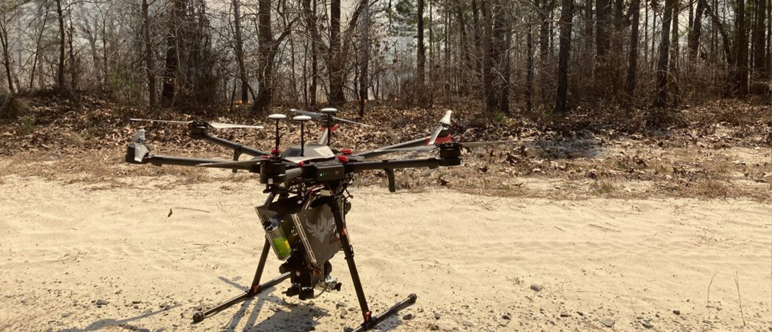
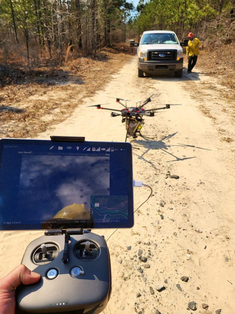
The Texas Parks and Wildlife Department, in conjunction with researchers at the University of Missouri, recently used UAVs mounted with forward-looking infrared cameras to count roosted birds across numerous regions and ecosystems in Texas. Some of the project's key objectives were to detect wild turkey populations and understand how population abundances can vary from region to region.
“There is no widely accepted method to estimate wild turkey population densities in an unbiased manner over a large enough scale that is practical to wild turkey management,” said Jason Hardin, TPWD’s wild turkey program leader. “However, UAVs can overcome many limitations associated with manned aircraft by flying surveys at low altitudes with minimal disturbance to roosting birds. This project was just as much about analyzing wild turkey populations as it was about testing the effectiveness of drones.”
Wild turkeys in various habitats and regions in Texas have been attached with GPS transmitters. Each evening, the GPS-marked bird is located within an hour of sunset and is tracked until it eventually settles in its roost. UAVs are programmed to fly multiple perpendicular transects or passes over and adjacent to the GPS-marked wild turkey within a fixed distance at about 30 meters above the forest canopy.
Some may ask, “why are you flying over a bird that you already know its location?” Wild turkeys are gregarious critters, so while one bird might be marked with a GPS, there are likely to be many other birds around, allowing TPWD to better gauge population densities and detectability.
"Flying over a known turkey allows us to determine if various habitats or environmental conditions (weather) affect the quality of thermal video and the detection of marked turkeys," said Allison Schmacher, University of Missouri graduate research assitant.
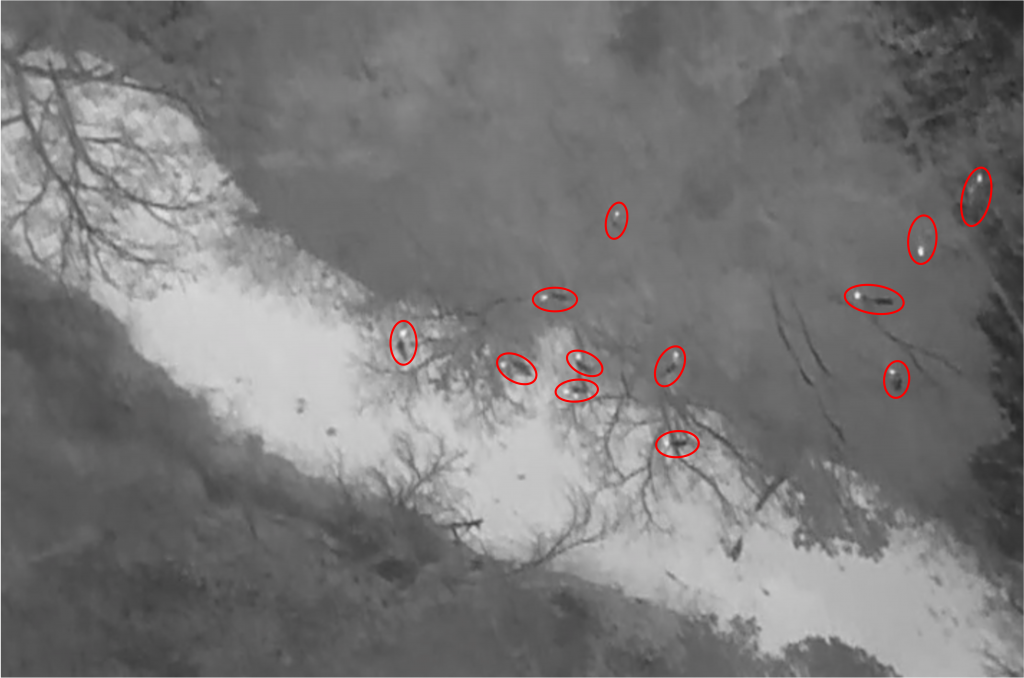
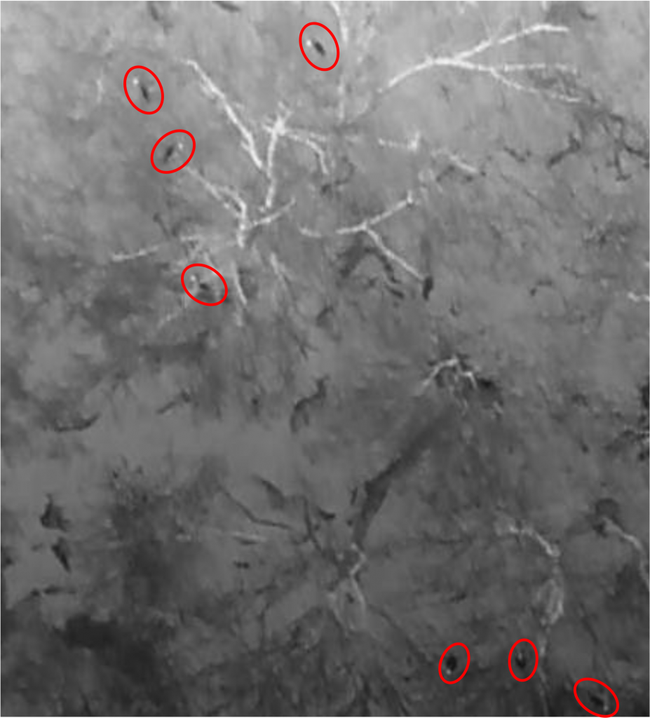
“Based on findings from the pilot study, about 30 meters above the canopy provides a reasonable trade-off between resolution of individual turkeys and area surveyed by the thermal infrared camera,” Hardin said.
The work at the University of Missouri is incorporating a machine-learning algorithm to help biologists assess the presence and density of roosted birds, allowing biologists to interpret drone footage more efficiently.
“The machine-learning algorithms are being designed to automate the process of counting the number of wild turkeys in a video,” said Michael Byrne, Ph.D., assistant professor of wildlife ecology at the University of Missouri. “By training an algorithm to automatically detect and count turkeys, we can make that process quicker and more repeatable on a large scale. When operational, a biologist would not be required to scrub through drone footage manually to identify and count every bird, which could be a very tedious and time-intensive task, and is also probably not great for one’s eyesight.”
In addition to counting turkeys through the footage, Hardin and the team are able to take note of certain landscape factors and correlate them with the density of wild turkeys. How does roost tree size affect population density? How does the harvest rate of a certain area affect the density? How does roost tree size and harvest rate, combined, affect population density? While the UAVs with infrared are providing TPWD with a new method to better gauge populations, it also opens a whole new possibility of inquiry to understanding wild turkeys, and that is a good thing.
Habitat Enhancements
And while drones are pushing the envelope in better understanding overall wild turkey ecology, they are also helping land managers deliver habitat enhancement projects.
Many habitat enhancement methods the NWTF engages in – including tree plantings, prescribed fire, invasive species removal, among others – are now being completed, to some degree, with drones.
For instance, the NWTF and the Tennessee Wildlife Resources Agency are utilizing drones to eliminate invasive species on three WMAs in Tennessee, ultimately benefiting 136 acres of wild turkey habitat.
Applying a selective herbicide allows land managers to be more precise and safer, as well as making the project more cost-effective.
“Drone applications can be more effective than on-the-ground methods because they can be done quicker, safer, and can be implemented in areas with limited access,” said Derek Alkire, NWTF district biologist for Alabama, Tennessee, and Kentucky. “This new technology is allowing us to make our members' dollars go even further by enhancing more wild turkey habitat.”
After the UAV aerial herbicide application on the WMAs in Tennessee, periodic prescribed fire will maintain an herbaceous-dominated plant community and allow these sites to remain optimum turkey nesting and brood-rearing cover, instead of being quickly overtaken by woody stems in the next growing season, which would be the case if they were mechanically mulched.
Likewise, the NWTF Georgia State Chapter recently contributed $22,050 to a drone that is capable of delivering largescale prescribed burns to enhance critical wildlife habitat.
“Helping the Georgia Department of Natural Resources purchase this state-of-the-art piece of equipment has been a great investment,” said Ricky Lackey, NWTF district biologist for Florida, Georgia and South Carolina. We are averaging about 3,000 acres a year of prescribed burns at a significantly lower cost than if we were using traditional methods.”
Wildlife Law Enforcement
The North Carolina Wildlife Resources Commission uses its UAVs for many purposes, including helping local sheriff departments, aiding the community and investigating instances where people violate wild turkey hunting laws.
“Recently, NCWRC drones were called out to assist in finding a gentleman with Alzheimer’s,” said NCWRC Lieutenant Brandon Coffey. “Utilizing the drone’s heat signature capabilities, they were able to locate the gentleman. Had we not used the drone, he would have perished.”
And while the agency has used the new tech to aid in public safety, even helping a local Sheriff’s department pursue a robbery suspect, the agency also utilizes the capabilities of UAVs to enforce wild turkey hunting regulations.
“Due to the nature of ongoing cases, I cannot provide specifics, but we have used drones to investigate instances of poaching,” Coffey said. “Their capabilities are used across our agency for wild turkeys, from law enforcement to helping count broods and locating nests for our biologists.
“Whether it is the great people of the commission, innovative technology or the awesome collaboration our department has with the NWTF North Carolina State Chapter, wild turkeys are thriving, and it is because all of us are passionate about the resource.”
Better understanding wild turkey ecology, making a difference in habitat quality or ensuring laws and regulations are enforced – UAVs offer an innovative approach to help conserve America’s greatest game bird. However, it is not just the technology itself that makes it a unique tool for conservation; it is the people using the technology who are always pushing the envelope to better conserve wild turkeys.